Martin Jakobsson is responsible for the North Sea in an initiative with the long name Nippon Foundation Gebco Seabed 2030. It is an effort to compile depth data from mainly echosound to a global map of the ocean floor.
Having control over the ocean depths is important not only for the currently highly topical energy and communication cables, but also for predicting how tsunamis arise and move and how coastlines are affected by climate change.
Despite humans having sailed the seas for thousands of years, we still have a very poor picture of what is down there. It was not until the breakthrough of sonar technology from the First World War and onwards that ships got a smooth way to read the underwater terrain.
A massive fjord
But Martin Jakobsson says that the blind spots are still many and large. Really large.
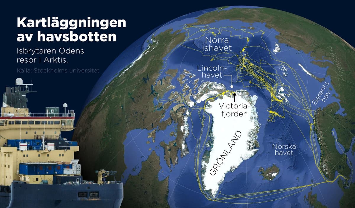
North of Greenland and the Canadian archipelago, for example, there are areas that are roughly the size of Sweden that are mapped with just a few points here and there. It's incredibly poor in some places, he says over the phone from Svalbard.
We were, for example, the first ship to enter Lincoln Sea and reach a fjord called Victoria Fjord last summer – it had never been visited by a ship before. And the fjord is enormous.
This can be seen as an illustration of how much work remains. How much nobody knows. Large amounts of ships are equipped with echosound that reads the environment down there, so a big part of Seabed 2030's work consists of getting operators, owners, and states around the world to share their data.
They contribute with data, we take care of it, says Jakobsson.
Then we have developed a "gridding". We call it gridding when you put together and make the model itself. We have developed a method that runs on supercomputers, goes through all these depth data points and creates a model of the ocean floor.
Abstaining from resolution
Despite the project being far from complete, the demand is already high. An example Jakobsson mentions is the communication and energy cables that are now being laid across the oceans and have become highly topical in the wake of suspected sabotage in, among other places, the Baltic Sea.
When we look at the spread of projected new underwater cables, then it's our data that is used as the basis in this first stage.
Seabed 2030, however, deliberately abstains from higher resolution in the data.
It also has to do with many nations seeing this as militarily strategic data, so we have, like, stopped where it starts to get too detailed, says Jakobsson.
We don't go into higher detail than a depth value every hundred meters.
Would have made a difference
What this means can be illustrated by the search for MH370, the passenger plane that disappeared over Asia in 2014 with 239 people on board and is believed to have crashed somewhere in the Indian Ocean. With Seabed 2030's resolution, the plane would not be visible on the ocean floor – but Jakobsson emphasizes that it would still have made a huge difference if these areas had been mapped then.
There, it was very poorly mapped. There were very few points, tens of miles apart and so on. And then you can't plan detailed investigations with underwater vehicles. You can't see the terrain.
It can thus be entire mountains, fully comparable to Sweden's largest, down there that nobody knows about. Which plays a role in many contexts.
When it comes to other things like how a tsunami propagates over the ocean floor, then you need this intermediate resolution so you can see that here comes topography that steers the tsunami this way or that. We provide data to that level.
Falling behind
The result can be seen if you zoom out on the oceans on electronic maps that most of us use.
Yes, absolutely, all those you see are basically our product, says Jakobsson – who, however, jokingly complains that the IT guys aren't quite keeping up.
Google Maps is actually falling behind.
I've seen that they haven't updated the latest up in the Arctic. I'll send an email to them that they need to be faster with their updates – they have full access to our "grid" that they use, he laughs.
Although we often talk about the world's oceans, there is actually only one – a global mass of saltwater that is connected and covers over two-thirds of our planet.
This global ocean can be relatively shallow in some areas, such as in our own inland sea, the Baltic Sea. But generally, it is very deep – on average over 3,500 meters. This means that it contains an enormous amount of water: over 97 percent of the world's water.
The largest part is the Pacific Ocean, which alone is larger than the entire land area of the Earth. There are also the deepest depths, in the Mariana Trench between Papua New Guinea and Japan. This curved underwater ravine, over 2,500 kilometers long, contains many places that are deeper than Mount Everest is high.
Sonar (from the English abbreviation "sonic navigation and ranging") is a technique for sending out sound and using echoes to map the surroundings.
The first users can be said to be certain animal species, such as dolphins and bats, which have navigated via echoes for millions of years. For humans, Leonardo da Vinci was early to use the technique, in the late 1400s. In modern form, sonar equipment was developed to handle the threat from submarines in World War I.