After World War II, the British Empire had a surplus of fighter pilots and aircraft. This coincided with a need to map the empire, so the pilots were sent on missions to take large quantities of photographs of places like Nigeria, Singapore, and Fiji.
The missions were called "cutting the grass". The aircraft flew back and forth, taking a new picture every 50 meters or so, which, when laid side by side, formed a mosaic snapshot of the entire country.
The flights took place regularly until the end of the 1980s. The images were collected in boxes that eventually ended up in a Scottish basement vault belonging to the National Collection of Aerial Photography (NCAP).
Andreas Madestam, professor of economics at Stockholm University, heard about the archive over a beer after a conference.
It sounded very interesting, but the question is what you can do with it, he says.
Mack-robots became the savior
Since the flights were made regularly - perhaps every tenth year - the images contain information about how cities have grown, how meandering rivers have been replaced by dams, and how agriculture and forests have developed since the 1940s. The archive contains material from 60 countries in Africa, Asia, and the Caribbean, many of which are developing countries with deficiencies in statistical data.
So we started talking to them at NCAP and said we wanted to raise money to try to digitize the images. And they said: "Okay, go ahead", says Anna Tompsett, lecturer at the Department of Economics.
Initially, the idea was to have people manually scan all the images over several years - but the salvation from the tedious task came from an unexpected source:
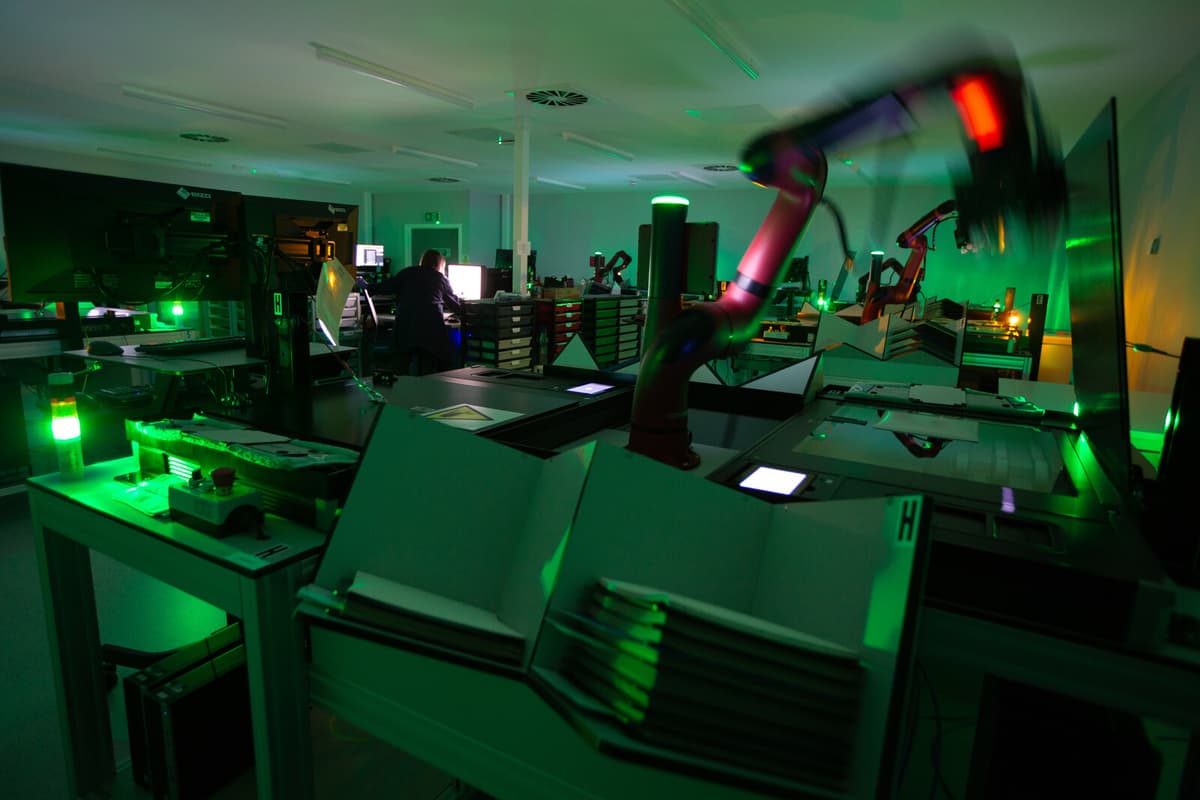
It came from the sandwich industry, where they have robot arms that can perform many different tasks. In our case, they were equipped with vacuum grips that lift one image at a time and place it on the scanner.
A large room in Edinburgh was adapted, and the robots were put to work.
At the fastest rate, they went through over a million scans in ten months. It's quite extraordinary, says Tompsett.
"Extremely detailed"
But what do you do with 216 terabytes of scanned, high-resolution photos? The original photographs were manually laid out as a puzzle in aircraft hangars, where they were then photographed from above to create maps.
It could be done manually by people on computers. But here's where AI comes into the picture. Colleagues at Berkeley and Caltech in the USA have created a tool that takes advantage of the fact that the images overlap slightly. By feeding in all the images taken during a specific flight mission, the algorithms search for distinct parts of them and stitch the images together into a map.
The maps can in turn be compared with later flight missions over the same area, all the way up to modern satellite images. One advantage is that the images continued to be taken even after the countries became independent, as part of British support to ex-colonies.
Satellite images are extremely detailed, but we have essentially the same level of detail, just in black and white, says Madestam.
On the images, you can see how many fishing boats were in Hong Kong's harbor in the 1940s, how large the glaciers on Kilimanjaro were in the 1950s, and how slum areas in Nairobi have grown. The urban population south of the Sahara has increased by 1,000 percent since the 1950s, and with the help of the images, it's possible to see how that growth has occurred.
Archaeologists can hunt for ruins that were visible before they were built over, and climate researchers can study the spread of glaciers.
This project allows us to, in a way, travel back in time and get a sense of how things looked before much of the development took place, and then follow it, says Madestam.
Questions every week
Every week, researchers from around the world come with inquiries, and the results of several studies on the material are waiting to be published.
The idea is to build a website where all the images are searchable for the general public.
A tempting way to look at it is, in principle, like a historical "Google Earth", where you can go back and forth in time and zoom in on different places, says Andreas Madestam.
Several research projects are already underway, linked to the aerial images, here are some examples of how they can be used in the future:
+ Follow the development of coastlines, rivers, and lakes - especially in areas that are experiencing long-term climate changes.
+ How glaciers change over time.
+ Understand what lies behind the growth of cities, and how they grow over time.
+ See how deforestation has occurred in certain areas in tandem with urbanization.
+ Archaeologists can discover old ruins that have been lost over the years, to see where it's worth doing excavations.
After World War II, there was a surplus of fighter pilots and aircraft in the UK. The Directorate of Overseas Surveys (DOS) was established and tasked with mapping the colonies, using aerial photographs.
Each photo covers an area between one square kilometer to 350 square kilometers, and was pieced together into large mosaics that formed the basis for the maps. As the areas developed, new, up-to-date images were needed.
Despite the colonies becoming independent, the flights continued, and were eventually expanded to cover 60 countries and around 1.7 million photographs, which have been scanned in recent years. The resolution is equivalent to satellite images, with an average of one pixel per square meter.
Copies of the images are still stored in an archive at the National Collection of Aerial Photography in Scotland.
DOS was disbanded in 2001.


